Rivers of West Bengal
Drainage systems
Drainage systems, also known as river systems, are the patterns formed by the streams, rivers, and lakes in a particular drainage basin. They are governed by the topography of the land, whether a particular region is dominated by hard or soft rocks, and the gradient of the land.
River system as a Introduction
- Ganges enters West Bengal near Rajmahal and then flows in a southeasterly direction.
- It divides into two near north of Dhulian in Murshidabad district.
- One branch enters Bangladesh as the Padma while the other flows through West Bengal as the Bhagirathi River and Hooghly River in a southern direction.
- The Bhagirathi is the main river in West Bengal which flows past some of the important cities like Murshidabad, Baharampur, Nabadwip, Chinsura, Chandannagar, Srirampur, Howrah, Kolkata, Diamond Harbour and Haldia. It releases its water into Bay of Bengal near Sagar Island in the South 24 Parganas.
- The Mayurakshi, Ajay, Damodar, Kangsabati, Rupnarayan and their tributaries which rise in the Western plateau and high lands flow eastwards through the different districts of West Bengal and joins the Bhagirathi on the right bank.
- The Mayurakshi, which is fed by tributaries Brahmani, Dwarka, Bakreshwar and Kopai joins the Bhagirathi near Kalna through river Babla, the Ajay, which rises in the hills of Jharkhand, being joined by the Kunur, flows down the plateau fringe, marking the boundary between Bardhaman and Birbhum districts joining it near Katwa and Damodar, with its small meandering distributaries, small streams, Khari, Banka and Behula joins the Bhagirathi near Uluberia.
- The Damodar known as the sorrow of Bengal, is now controlled after formation of the Damodar Valley Project. The Dwarakeswar and Shilabati rivers join to form Rupnarayan and the Kangsabati and Keleghai rivers join to form the Haldi.
- The Rupnarayan and Haldi fall into the Bhagirathi in the Purba Medinipur district. The Subarnarekha river entering from Jharkhand and after flowing for a short distance in West Bengal re-enters into Orissa.
- These rivers carry plenty of water thus keeping the Bhagirathi river with optimum water throughout the year.
- The rivers along with water carry silt and sand eroded from the western plateaus and deposits them in the Bhagirathi and the rivers themselves.
- This silting is causing great inconvenience for the Kolkata Port and often results flooding in the years of heavy rain.
- The distributaries of the Padma River like Bhairab, Jalangi, Mathabhanga river and their tributaries enters West Bengal and joins the Bhagirathi on its left bank.
- The Bhairab and the Jalangi meet and their joined course known as Jalangi falls into Bhagirathi.
- The Mathabhanga divides into branches namely; Churni and Ichhamati, The river Churni meets the Bhagirathi while the other flows southwards and joins the Kalindi. The Sunderbans region is covered by numerous estuaries and streams, mainly distributaries of main rivers. The rivers are interconnected and are fed by tidal waters. The major rivers of the area are Hoogly, Matla, Gosaba, Saptamukhi, Haribhanga, Piyali, Thakuran/ Jamira, Raimangal, Kalindi and Ichhamati.
- The Teesta flows cutting deep gorges from north to south in the mountainous Darjeeling district, it enters the plains at Sevoke and flows in a mighty stream on straight line towards the south east until it drains its water into the Brahamaputra in Bangladesh.
- Torsa, Jaldhaka, Kaljani, Raidak, Sankosh and Mahananda rivers are in the northern hilly region which rise in the Himalayas and flow in a southerly direction through the districts of Darjeeling, Jalpaiguri, Cooch Behar and North and South Dinajpur and enters Bangladesh.
- As most of the rivers are snow fed, most of the rivers are perennial in nature and often floods during the rainy season.
- The entire region is made up of sand, gravel and pebbles laid down by these rivers.
- The Mahananda rises from the Dow Hills forest, near the town of Darjeeling and are fed by similar small rivers like, Mahanadi, Balason, and Mechi and runs in a zig-zag way through the district of Malda and joins the Padma in Bangladesh.
- In the central region, the main river is the Mahananda. The Tangon, Punarbhabha, and Atrai arises in the plains, while the former two joins together and flows into Mahanadi, Atrai flows into the Padma.
RIVER BASINS of Rivers of West Bengal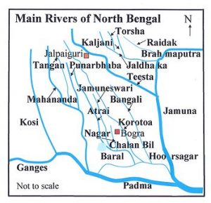
- The state can be demarcated into three distinct drainage basins coming under the Ganga, Brahmaputra and Subarnarekha system respectively.
- These three main river basins can in turn be divided into Subbains having individual catchment of their own.
- The area-wise distribution of the above main basins in the state are as under:–
- Brahmaputra Basin (11, 860 sq.km.)
- Ganga Basin including Sundarban Area (74, 732 sq.km.)
- Subarnarekha Basin (2, 160 sq.km)
Brahmaputra Basin Drainage System
- The rainfall in the northern region of the state is generally high.
- The ground slope is steep, particularly in the Sub-Himalayan regions of the northern districts.
- Except Darjeeling, all the areas belong to Brahmaputra Basin.
- This system consists of a total area of 11,860 sq.km. nearly 14% of the geographical area of the state.
- This basin area is interspersed with a large number of drainage channels which join the main drainage arteries of the regions like the rivers Teesta, Torsa, Raidak, Mansai, Jaldhaka etc.
- All these rivers originate from the Himalayas in Bhutan/Sikkim and flow across the Terai region and reach the plains of West Bengal and then flow to Bangladesh joining ultimately the Brahmaputra in Bangladesh.
- The rivers feeding the river Brahmaputra have number of tributaries as given in the following table:
| S. No. | River Basin | Catchment area in sq.km. (in West Bengal) | Tributaries |
| 1 | Sankosh | 172 | Chiklajhore |
| 2 | Raidak | 807 | Raidak-I, Raidak-II, Turturi |
| 3 | Torsa | 3419 | Kaljani, Sil-Torsa, Char-Torsa, Dolong, Sanjai, Ghargharia, Garam, Diana, Pana, Jainti, Gabur-Basra |
| 4 | Jaldhaka | 3746 | Mujnai, Murti, Diana, Sutanga, Dolong, Dharala, Ghatia, Kumlai, Gilandi, Duduya |
| 5 | Teesta | 3716 | Great Rangeet, Ramam,Rangpoo, Mechi, Leesh, Ghish, Chel, Mal, Neora, Karala. |
BRIEF DESCRIPTION OF RIVERS UNDER BRAHMAPUTRA BASIN
SANKOSH
- The river Sankosh with its origin in Bhutan is the eastern most river of Brahmaputra river basin.
- It serves as the boundary between the two states West Bengal and Assam.
- It joins with Raidak-II and finally falls into Brahmaputra in Bangladesh by name Gangadhar.
RAIDAK
- It originates in Mt. Akungphu at an altitude of 6400 m. in Bhutan.
- The river Raidak then bifurcates into two channels namely Raidak-I and RaidakII at Bhutanghat, close to Indo-Bangladesh border.
- Raidak-I joins the united stream of Torsa and Kaljani, while Raidak-II is joined by Sankosh and finally outfalls into Brahmaputra in Bangladesh by the name Gangadhar.
TORSA
- The river Torsa originates in Chumbi Valley of southern Tibet at an altitude of 7065 m.
- It flows through Tibet, Bhutan, West Bengal and Bangladesh.
- Below Hasimara bridge on NH-31, it bifurcates into two channels viz. Sil-Torsa and Char-Torsa. They reunite at Patla Khowa forest.
- The river passes by the Coochbehar town and is joined by river Kaljani and Raidak-I.
- The combined flow outfalls into Brahmaputra near Nageswari at Rangpur in Bangladesh.
JALDHAKA
- The river Jaldhaka has its origin at Bitang Lake in Sikkim at an altitude of 4400 M.
- It flows through Sikkim, Bhutan, West Bengal and Bangladesh.
- After the river is joined by a number of streams and tributaries both in mountainous and sub-mountainous regions, it finally flows into river Dharala and the combined system, by the name Dharala ultimately outfalls into Brahmaputra in Bangladesh.
TEESTA–
- The mighty river of North Bengal originates in the glaciers of North Sikkim at an altitude of 6400 M and is formed by the union of two streams viz.
- Lachen and Lachung at Chungthung in Sikkim.
- It enters West Bengal at Rangpoo and upto Mechi, it forms the boundary betwen West Bengal and Sikkim.
- Two of its tributaries-Great Rangit and Rammam also serve as the natural boundary between the two states.
- The river finally outfalls into Brahmaputra in Rangpur district of Bangladesh.
GANGA BASIN
- The two holy rivers – Bhagirathi and Alakananda originating from the glaciers of the Himalayas at an altitude of 7000 M. join at Dev prayag and the combined stream is known as the Ganga.
- It emerges into the plains at Rishikesh in Uttaranchal.
- After flowing exclusivelly through Uttaranchal and Uttar Pradesh it receives the flow of Yamuna, the largest tributary at Allahabad.

- The Ganga forms the boundary between Uttar Pradesh and Bihar for a length of about 110 km. and the river then enters Bihar and flows more or less through the middle of the state.
- After its confluence with the Kosi, the Ganga continues its eastward flows in Bihar for about 40 km. and then it enters West Bengal.
- As it enters West Bengal, the river swings round the Rajmahal hill range and then starts flowing almost due south.
- The river then bifurcates into two arms about 40 km. below Farakka.
- The left arm called the Padma flows eastwards into Bangladesh while the right arm called Bhagirathi continues to flow south through West Bengal.
- The stretch of the river after Nabadwip is called Hooghly and ultimately outfalls into the Bay of Bengal near Sagar Island.
- The Central, Southern and the South-Western parts of the State of West Bengal constitute the Ganga Basin.
- The total length of the river Ganga from its point of origin to the point where it falls into sea is about 2575 km (measured along Bhagirathi and the Hooghly), of which 1450 km lies in Uttaranchal and Uttar Pradesh, 110 km along Uttar Pradesh and Bihar border, 445 km in Bihar and 570 km in West Bengal.
- The Ganga system comprises a total area of 74,732 sq.km. within the state of West Bengal.
MAHANANDA
- The river Mahananda originates from Ghoom near Darjeeling town in the district of Darjeeling.
- The Mahananda river system lies between latitude 25º15′ N to 26º15′ N and longitude 87º45′ E to 88º15′ E.
- It is bounded on the north by the Himalayas, in the east by the ridges separating it from Teesta river system, the river Ganga on the South and the Kosi river system in the east.
- The river bifurcates into two channels at Barsoi in Bihar.
- Out of the two branches one flows through Bihar by the name Fulahar and the other flows through West Bengal as Mahananda.
- The river Mahananda carrying the flow of four tributaries namely, Nagar, Kalindri, Tangon and Punarbhaba, drains into the river Ganga from the North-Western side at Godogarighat just downstream of the point where Ganga leaves the boundary of West Bengal.
ATRAI-PUNARBHABA
- Some rivers like Sahu, Neem, Talma, Chaoai, Panga originating from the high lands in districts of Jalpaiguri, meet together afterwards.
- This combined stream assumes the name Karotowa.
- It then enters Bangladesh by the name Atrai.
- The river Atrai then bifurcates into two channels namely Dheepa and Atrai.
- The Western Channel – Atrai re-enters West Bengal in South Dinajpur district covering a length of 40 km. in the state.
- It again enters into Bangladesh and ultimately outfalls into river Brahmaputra. The Dheepa on the other hand taking a South – Westernly course enters Gangarampur P.S. in South Dinajpur district assuming the name Punarbhaba.
- Covering a length of about 40 km. in the district it touches the eastern boundary of Maldah district and finally enters Bangladesh.
- Further down, Punarbhaba meets the river Mahananda in Bangladesh.
NAGAR-KULICK, GAMARI-CHIRAMATI, TANGON, KALINDRI
- All these rivers flow through the districts Malda and North Dinajpur.
- In course of their flow, somewhere they form the boundary either between West Bengal and Bihar or between West Bengal and Bangladesh.
- These rivers ultimately outfall into the river Mahananda. Nagar, originating in Bangladesh flows along the boundary of West Bengal and taking a South-easternly course, receives a spill channel of Mahananda and is joined by Kullick, which has also its origin in Bangladesh.
- Gamari and Chiramati are two small rivers that flow through North Dinajpur district before they are united.
- This combined stream finally outfalls into the river Mahananda. Tangon is a tributary of river Mahananda. It rises in Bangladesh.
- It flows through the district of North Dinajpur and Malda and meets Mahananda on the boundary of Malda and Bangladesh.
PAGLA-BANSLOI-BRAHMANI
- These rivers originate from the Rajmahal hills in the district of Bihar.
- Flowing easternly across Birbhum district, they entered Murshidabad district as the tributaries of the river Bhagirathi.
JALANGI-BHAIRAB
- The river Jalangi originates from the right bank of the river Padma in Murshidabad district, 165 km. downstream of Farakka.
- Jalangi is dead for all purposes except during the periods of rain, when it receives water from Padma.
- The river ends its journey by finally outfalling into the river Hooghly near Nabadwip town in Nadia district in West Bengal.
- The river Bhairab starts its journey from the river Ganga in P.S. Lalbag of Murshidabad district.
- It is now almost a dead channel but during rainy season it receives water from Padma.
ICHAMATI-CHURNI
- The river Mathabhanga originates from the mouth of the Jalangi of Padma.
- It is not an important river in this stage, as it flows mainly through Bangladesh. It flows only a few kilometers within the district of Nadia.
- At this stage, the river bifurcates into two streams – the eastern course runs a few kilometres through the districts in a south-east direction to meet Bhagirathi by the name Churni and the other course flows by the name Ichamati.
- Ichamati gets a little supply from Padma and thrives on wash out by tidal flows
BHAGIRATHI-HOOGHLY
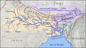
- The Ganga Brahmaputra Meghna river system constitutes one of the largest river systems of the world in terms of its water resources.
- The river Ganga originating in the Himalayas in India, drains a vast area. Near its deltaic head at Farakka it divides into two channels, the Bhagirathi-Hooghly and the Padma.
- The Bhagirathi-Hooghly flows through West Bengal and outfalls in Bay of Bengal and the Padma crosses over into Bangladesh and joins the Brahmaputra at Goalundo.
- The river Bhagirathi divides the Murshidabad district into two parts. It receives three right bank tributories namely the Bagmari-Pagla, the Mayurakshi and the Ajoy.
- It receives the Jalangi just upstream of Nabadwip town from the left. After its confluence with the Jalangi, the Bhagirathi is known as the Hooghly.
- The Bhagirathi-Hooghly is the main river in the state and is the main drainage artery for the southern districts draining almost the entire area.
- Before 12th century, the Ganga had its main course down BhagirathiHooghly. Subsequently, the main flow was pushed to the east through the present course of Padma.
- The flow of Bhagirathi increases downstream due to the run off and outflows receives from a number of eastern and western tributaries.
- It also forms the boundary between 24-Parganas and Hooghly districts.
MAYURAKSHI-BABLA
- Mayurakshi originates from the high lands of Santhal Parganas.
- It is the main river of Birbhum district. Several spill channels – the Manikornika, Kana Mor, Gambhira etc. take off from the Mayurakshi in its lower reaches.
- All these rivers flow into the lower pocket of Hijal Beel in the district of Murshidabad.
- From the Beel, the river Babla starts its journey finally draining into the river Bhagirathi.
- The drainage and flood level in the Hijal Beel is considerably influenced by the level rulling in the Bhagirathi.
AJOY
- The river Ajoy originates from the hills near Deoghar in Jharkhand.
- The Principal tributaries of the river are – Hinghlow, Kunoor, Pathro and Jayanti.
DAMODAR
- The river Damodar originating from Palamau hills in Jharkhand and bifurcates into two channels at Beguahana.
- The main flow passes through Mundeswari channel and discharges into Rupnarayan.
- The other one Amta channel carries discharge during high flood and outfalls into the Hooghly.
DWARAKESWAR-SILABATI-RUPNARAYAN
- Dwarakeswar originates from the high lands of Purulia district.
- River Ganddheswari rising from Bankura district meets Dwarakeswar near Bankura town receiving water from streams like Arkasha, Berai, enters Hooghly district and meets Silabati to form Rupnarayan. Silabati also originates in Purulia district.
- It traverses through the district of Midnapore.
- The river receives water of Joypanda and meets with Dwarakeswar to form Rupnarayan. Rupnarayan is a combination of number of streams.
- The tidal reach below confluence of Dwarakeswar and Silabati is known as Rupnarayan.
- It outfalls into Hooghly after receiving mainflow of Damodar through Mundeswari and branch of Kangsabati.
- The river is tidal throughout its entire course.
KANGSABATI-KALIAGHAI-HALDI
- The river Kangsabati originating from Purulia district is joined by Kumari in Bankura district.
- Further down, it is joined by the combined streams of Bhairab Banki and Tarafeni rivers and thereafter it flows through the Midnapore district. After a tortuous course, it bifurcates.
- The upper branch known as old Cossye or Palaspai Khal outfalls into the Rupnarayan and the other one is known as New Cossye.
- The river Kaliaghai trickles out from Jhargram, P.S. in Midnapore district. During the course of its journey, it is fed by the flow of its tributaries namely Kapaleswari, Baghai and Chandia.
- This combined flow meets the other arm of Kangsabati i.e. New Cossye to form Haldi.
- The river Haldi formed by joining of New Cossye and the combined flow of Kaliaghai outfalls into the river Hooghly. The lower portion of the river Haldi is affected by over bank spills and drainage problem during the monsoon.
RASULPUR
- The river Rasulpur is formed by three streams namely Bagda, Sarpai and Madhakhali.
- It is the main river of Contai Sub-Division of Midnapore district.
- It acts as the main drainage for Dwarakeswar, Silabati and large portion of the Kangsabati rivers.
- It causes flooding in two regions namely Dubda and Contai areas.
- The river ultimately falls into the river Hooghly
TIDAL RIVERS OF SOUTHERN WEST BENGAL
- Apart from the rivers described earlier within the Ganga and the Brahmaputra river systems, there is a group of rivers in Southern part of the State which falls in the deltaic zone.
- These rivers mostly lie in the deltaic zone to the east of the Hooghly river popularly known as Sundarbans and form an intricate network with a number of criss-cross inter connecting channels, thus dividing the land spill channels of Ganga, then upland supply running dry, during winter months. But gradually their off-takes from Ganga have deteriorated and in some cases being cut-off from the river.
- Now these rivers drain off whatsoever fresh discharge comes from country sides, thus ultimately draining into Bay of Bengal through one or other of the principal estuaries in the area which are, starting from Hooghly river successively the Bartala of Muriganga or channel creek, Saptamukhi, Matla, Gosaba, Hariabhanga, Raimongal etc.
- The Tolly’s Nullah or the Adi Ganga, as it is sometimes called is a small but important tidal creek draining into the Hooghly from the left in the vicinity of the city of Kolkata
- WBPCS Mains Tests and Notes Program
- WBPCS Prelims Exam 2020- Test Series and Notes Program
- WBPCS Prelims and Mains Tests Series and Notes Program
- WBPCS Detailed Complete Prelims Notes