Rajasthan geographical location:-

- Rajasthan, located at the northwestern part of India is the biggest state in the country. This colossal state has an area of 3,42,239sq.km encompassing 11% of the total geographical area of the country. In fact Rajasthan’s area is similar to that of Western countries like Italy (3, 01,200 sq. km.), Norway (3, 24,200 sq. km) Poland (3, 12,600 sq. km.). Rajasthan lies between latitudes 23 degree 3’and 30 degree 12′, north and longitudes 69 degree 30′ and 78 degree 17′, east. Compared to many other countries located in a similar latitudinal belt, such as in northern Arabia, Rajasthan has a less harsh climate. The State’s scorching and dry summers and its parched landscape are undergoing significant changes because of the developmental effort that have led to the spread of the Indira Gandhi Nahar.
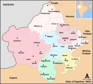
- Rajasthan has an a typical rhomboid shape and stretches lengthwise 869 km. from west to east and 826 km. from north to south. It shares its north-western and western boundary with the Indo-Pakistan international border that extends about 1,070 km and touches the major districts Barmer, Bikaner, Ganganagar and Jaisalmer. Altogether Rajasthan has 32 districts.
- The states of Haryana, Uttar Pradesh and Punjab bound the state of Rajasthan in the north and northeast. Uttar Pradesh and Madhya Pradesh lie on the east while the state of Gujrat is located at the southwest of the state.
- Rajasthan’s geographical area is marked with diversity and is characterized by rolling sand dunes, fertile plains, rocky undulating land and some forested regions. The huge portion of the state of Rajasthan is desiccated and houses the biggest Indian desert- the Thar Desert known as the ‘Maru-kantar’.Only 9.36% of the total geographical region lies under forest vegetation.
- The western area of Rajasthan being mostly barren encloses the Great Indian Thar desert. However the terrain is rocky and is much wetter and fertile in the southeastern part. Cotton, foodgrains, oilseeds and sugarcane are grown in the fertile tracts that are utilized as agricultural regions. The western region has also some wooded portions and water bodies.
Large areas in the Sabhar region have rich deposits of salt and Khetri and Dariba have many copper mines.
- The main geographic feature of Rajasthan is the Aravalli Range, which runs across the state from southwest Guru Peak (Mount Abu), which is 1,722 m in height to Khetri in the northeast, for more than 850 km. This divides Rajasthan into 60% in the North West of the lines and 40% in the southeast. The northwest tract is sandy and unproductive with little water but improves gradually from desert land in the far west and northwest to comparatively fertile and habitable land towards the east of India. The area includes the Great Indian (Thar) Desert. Mount Abu is at the southwestern end of the range, separated from the main ranges by the West Banas River, although a series of broken ridges continues into Haryana in the direction of Delhi where it can be seen as outcrops in the form of the Raisina Hill and the ridges farther north of India. About three-fifths of Rajasthan lies northwest of the Aravallis, leaving two-fifths on the east and south of India.
- The south-eastern area, higher in elevation (100 to 350 m above sea level) and more fertile, has a much diversified topography. In the south lies the hilly tract of Mewar of Rajasthan, in the southeast a large area of the districts of Kota and Bundi forms a tableland, and to the northeast of these districts is a rugged region (badlands) following the line of the Chambal River. Further north the country levels out; the flat plains of the northeastern Bharatpur district are part of the alluvial basin of the Yamuna River in India.
- In the vast sandy north-western plain extending over the districts of Jaisalmer, Barmer, Jalor, Sirohi, Jodhpur, Bikaner, Ganganagar, Jhunjhunu, Sikar, Pali, and Nagaur in Rajasthan’s soils are predominantly saline or alkaline. Water is scarce but is found at a depth of 30 to 61 m. The soil and sand are calcareous (chalky). Nitrates in the soil increase its fertility, and, as has been shown in the area of the Indira Gandhi Canal (formerly Rajasthan Canal), cultivation is often possible where adequate water supplies are made available.
- The main source of water for the fields in Rajasthan, are the irrigation dams or deep wells. There is also some forest area in Rajasthan comprising of the forests of Alwar, Bharatpur and Sawai- Madhopur. In these forests, you can find blue bull, tiger, wild boar, panther, deer and so on. Rich alluvial soil makes up the level and flat plains in this area. The major cultivation in Rajasthan consists of wheat, maize, paddy and sugarcane in Kota and Bundi, in the Chittorgarh and Bhilwara districts.
WBPCS Notes brings Prelims and Mains programs for WBPCS Prelims and WBPCS Mains Exam preparation. Various Programs initiated by WBPCS Notes are as follows:-
- WBPCS Mains Tests and Notes Program
- WBPCS Prelims Exam 2020- Test Series and Notes Program
- WBPCS Prelims and Mains Tests Series and Notes Program
- WBPCS Detailed Complete Prelims Notes