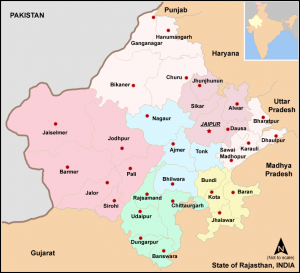
Divisions and Districts of Rajasthan
- Total Districts: 33
- Total Panchayat Samities: 295
- Total Gram Panchayats: 9891
The detail analysis of Population Census 2011 published by Govt. of India for Rajasthan state reveal that population of Rajasthan has increased by 21.31% in this decade compared (2001-2011)
24.9-48.3 48.6-11.4 42.9-11.4 132.3-11.4 132.3s0 89.4 11.4 132.3c6.3 23.7 24.8 41.5 48.3 47.8C117.2 448 288 448 288 448s170.8 0 213.4-11.5c23.5-6.3 42-24.2 48.3-47.8 11.4-42.9 11.4-132.3 11.4-132.3s0-89.4-11.4-132.3zm-317.5 213.5V175.2l142.7 81.2-142.7 81.2z"/>
Subscribe on YouTube
to past decade (1991-2001). The density of Rajasthan state in the current decade is 519 per sq mile.
- Rajasthan is an State of India with population of Approximate 6.86 Crores.
- The population of Rajasthan state is 68,548,437.
- The density of Rajasthan state is 200 per sq km.
- Rajasthan State is spread over 342,239 Sq Km.
- The Indian state of Rajasthan is divided into 33 districts for administrative purposes.
- The responsibilities of district management are carried out by All-India officials and state-appointed officials.
- The All-India officials in each district are a Deputy Commissioner or district Magistrate (from the Indian Administrative Service), a Superintendent of Police (from the Indian Police Service) and a Deputy Conservator of Forests (from the Indian Forest Service), each of which is assisted by officers of various Rajasthan state services.
- The state-appointed officials are responsible for matters such as health, education, and agriculture in each district.
The 33 districts are grouped into seven divisions:
| Division |
Districts |
| Jaipur |
- Jaipur
- Alwar
- Jhunjhunu
- Sikar
- Dausa
|
| Jodhpur |
- Barmer
- Jaisalmer
- Jalore
- Jodhpur
- Pali
- Sirohi
|
| Ajmer |
- Ajmer
- Bhilwara
- Nagaur
- Tonk
|
| Udaipur |
- Udaipur
- Banswara
- Chittorgarh
- Pratapgarh
- Dungarpur
- Rajsamand
|
| Bikaner |
- Bikaner
- Churu
- Sri Ganganagar
- Hanumangarh
|
| Kota |
- Baran
- Bundi
- Jhalawar
- Kota
|
| Bharatpur |
- Bharatpur
- Dholpur
- Karauli
- Sawai Madhopur
|
Districts of Rajasthan with Their HQ
| District |
Headquarters |
Area (km²) |
Population (2011) |
Division |
|
| Ajmer |
Ajmer |
8,481 |
2,584,913 |
Ajmer |
| Alwar |
Alwar |
8,380 |
3,671,999 |
Jaipur |
| Banswara |
Banswara |
5,037 |
1,798,194 |
Udaipur |
| Baran |
Baran |
6,955 |
1,223,921 |
Kota |
| Barmer |
Barmer |
28,387 |
2,604,453 |
Jodhpur |
| Bharatpur |
Bharatpur |
5,066 |
2,549,121 |
Bharatpur |
| Bhilwara |
Bhilwara |
10,455 |
2,410,459 |
Ajmer |
| Bikaner |
Bikaner |
28,466 |
2,367,745 |
Bikaner |
| Bundi |
Bundi |
5,550 |
1,113,725 |
Kota |
| Chittorgarh |
Chittorgarh |
10,856 |
15,44,392 |
Udaipur |
| Churu |
Churu |
13,858 |
2,041,172 |
Bikaner |
|
| Dausa |
Dausa |
3,432 |
1,637,226 |
Jaipur |
| Dholpur |
Dholpur |
3,033 |
1,207,293 |
Bharatpur |
| Dungarpur |
Dungarpur |
3,770 |
1,388,906 |
Udaipur |
| Hanumangarh |
Hanumangarh |
12,645 |
1,779,650 |
Bikaner |
| Jaipur |
Jaipur |
14,068 |
6,663,971 |
Jaipur |
| Jaisalmer |
Jaisalmer |
38,401 |
672,008 |
Jodhpur |
| Jalor |
Jalore |
10,640 |
1,830,151 |
Jodhpur |
| Jhalawar |
Jhalawar |
6,219 |
1,411,327 |
Kota |
| Jhunjhunu |
Jhunjhunu |
5,928 |
2,139,658 |
Jaipur |
| Jodhpur |
Jodhpur |
22,850 |
3,685,681 |
Jodhpur |
| Karauli |
Karauli |
5530 |
1,458,459 |
Bharatpur |
| Kota |
Kota |
5,446 |
1,950,491 |
Kota |
| Nagaur |
Nagaur |
17,718 |
3,309,234 |
Ajmer |
| Pali |
Pali |
12,387 |
2,038,533 |
Jodhpur |
| Pratapgarh[2] |
Pratapgarh |
4,117 |
868,231 |
Udaipur |
| Rajsamand |
Rajsamand |
4,768 |
1,158,283 |
Udaipur |
| Sawai Madhopur |
Sawai Madhopur |
10,527 |
1,338,114 |
Bharatpur |
| Sikar |
Sikar |
7,732 |
2,677,737 |
Jaipur |
| Sirohi |
Sirohi |
5,136 |
1,037,185 |
Jodhpur |
| Sri Ganganagar |
Sri Ganganagar |
11,154 |
1,969,520 |
Bikaner |
| Tonk |
Tonk |
7,194 |
1,421,711 |
Ajmer |
| Udaipur |
Udaipur |
13,883 |
3,067,549 |
Udaipur |